It's been almost two weeks since I completed my epic Tom Thomson Unicycle Trip. I had provided updates on my Facebook profile, but several friends expressed keen interest in a blog report. Others are speculating that with no blog report I never actually did complete the trip and was lost to perdition. This blog entry should put these rumours to rest and set the record straight on my achievement.

Now the adventure:
It started exactly as planned. I departed 8:00am sharp on Friday May 7th, 2010. In hindsight, I am glad that I pushed my date up one day because Saturday offered the absolute worst weather that the month of May could offer (wind warnings, hail, snow, rain, and freezing temperature).
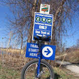
But Friday morning weather was perfect, a little on the chilly side and no wind, hence, perfect for unicycling. In the above photo, I am posing in front of the Tom Thomson Trail Head Kiosk in Meaford. Here is the link to the official trail map and my Google Maps interpretation of the Tom Thomson Trail.
The trail commenced at the Meaford Harbour and the first two kilometers cut through the streets of Meaford proper. An easy start but what I didn't bargain for was the steep hill by the hospital on Nelson Street. A quick glance on my heart rate monitor showed 160 bpm. If this number kept climbing at least the hospital was close by. Fortunately, I completed the hill quickly; I was so focused on the road that I didn't notice my father behind me who snapped the photo below.

Soon, I was out of Meaford, onto County Road 12. It was about 8:30am when all of the yellow school buses started to roll by. I managed to catch a few excited glances out of the school bus windows. Two kids waiting on the road didn't quite know what to make of me, nor did an unleashed dog gather its sensibilities in time to chase me.
Progress on County Road 12 was superb and picturesque. The chip and tar pavement was fine for a good pace and the relative smoothness afforded me some sightseeing along this road. The grazing cows also did not know what to make of me and I had the rapt attention of my biggest (bovine) audience ever.
Soon the road turned into Sideroad 16 and tar and chip gave way to gravel road. It was still relatively easy riding. But soon the tide began to turn...
The first indication was the sign below.

The "No Winter Maintenance" did not worry me, it was the "NO EXIT" proclamation. The latter had the tone of "Abandon all hope, ye who enter here". My imagination started to fire up and I began the unicyclist's interpretation of Pilgrim's Progress ( There is a Slough of Despond but that is on another route in Grey County).
Shortly thereafter, I met a hill too step for me to climb. I had to walk the last 50m to the summit. Then another big hill beyond my ability; I had to walk the last 250m. I began to curse glacial formations (I was surmounting drumlins beyond my abilities).
I passed a lone pedestrian (are they called pedestrians in these parts?) going in the opposite direction. I offered an apologetic grunt in passing: "The hill got the better of me." The reply was a stare of disbelief. I kept on moving, and mounted my unicycle as soon as glacially possible.
The road (it was now gradually degrading to a trail) was fine for the next few kilometers. Then it started getting really rough and technical. On the map Sideroad 16 looks straight but that was the surveyor's dream for this road. This wishful straightfulness was rather a series of bends switchbacks which forced me to dismount and re-mount numerous times. Just over an hour into the trip, it was at this point that I started to realize the magnitude of effort this trail would require should this be the road condition from now on. I took solace in the fact that I still had 3G coverage should anything go seriously awry. Perhaps this was the road to perdition but surely a Facebook friend would rescue me, if the need arose...
I turned onto the Sydenham/St. Vincent Town Line. I consider this this is the Mason Dixon line between Meaford and Owen Sound. Since the amalgamation, Meaford's jurisdiction has reached far beyond this line into what I consider Owen Sound's sphere of influence (including my home village of Leith), but that too is another story to be told.
The Sydenham/St. Vincent Town Line (hah!) in all its glory is below:

As you can see, the Town Line has large mud puddles with attitude. I have learned that mud puddles can hold some pretty nasty surprises for unicyclists, so I chose to dismount and walk around the bigger puddles. On one occasion my unicycle did land smack in the middle of a puddle but I managed to avoid the same. At least there's no chain to clean. Once this nasty stretch was behind me, I crossed Highway 26 and continued northward. I was reunited with a smoother tar and chip surface but with over 2 hours into the ride my butt started to hurt. But it wasn't enough to stop so I experimented with several creative weight-shifting positions on the saddle (left-hand only, right-hand only, both hands, lean back as far as possible with no hands, etc.)
The Town Line started to butt up (no pun intended) against the Niagara Escarpment. I encountered another steep hill where I had to walk up the last few meters. Then the road followed round the Escarpment, and suddenly I was treated to a wonderful vista of the farms in the township along with the distant islands on Georgian Bay (Griffith, Hay and White Cloud Island). I would have taken a picture, but I was concentrating on shifting the weight on my butt.
The road then began to track along the most westerly boundary of the Meaford Tank Range (as I still call it). Because of its similarity to northern France, The Meaford Tank Range was expropriated in 1942 for training preparation for D-Day. When I was a kid, I considered the Tank Range boundary as the end of the world.

Along this stretch, I was constantly reminded I was beside a forbidden zone, limited to horses only ("hors limites" as the lower-half of the sign says). This is where I stopped for lunch, discovered I had 3G coverage no longer. I half-expected a military person on a horse to suddenly appear to question my presence and my peculiar mode of transport. I was getting delusional; lunch fixed that.
After lunch, I turned onto Sideroad 30 going westbound. Not a difficult road, but a long and gradual descent towards Owen Sound Bay. Regular cyclists welcome these descents, but that is not so for unicyclists. On a unicycle there is no such thing as coasting, and descents require a constant back-pressure on the pedals. Not a big issue for short descents, but over long distances it adds up to quite a strain on the knees and I really started to feel it after 6-7 kilometers of descent.
My next major stop was at my parent's property in the township.

My parents have a garden here where they grow beans and tomatoes, not marijuana, as numerous other secret plots in the township are wont to do. It was at this point, I regained 3G coverage and called my parents to let them know I was out of danger of perdition. I reported that I would be arriving at the Leith Church around 12:30pm (4.5 hours into my trip). My progress was exactly as planned, I was a bit ahead of schedule, so I did some leisurely unicycle sightseeing in the village of Leith (about 3 minutes worth). Aside from the Leith Church, the village main attraction is the Leith Bridge (below).

After sightseeing, I unicycled to the Leith Church and its cemetery. As for its personal significance, you may wish to read my previous blog entry.

It was at Leith Church that I had arranged for the Sun Times Newspaper photographer, James Masters to snap a few pictures (James is also a good friend of mine from high school). James was scheduled to arrive a 1:00pm so I had a few minutes to spare. My parents arrived and we toured the cemetery and paid our respects to former neighbour and my cousin (first cousin once removed), Findlay Bergstra who passed away in 2006.

Although Tom Thomson's grave site is here (just 50m away), Findlay's resting place has much more significance to me and paying respect to Findlay is the primary reason for visiting Leith Cemetery.
We commenced the photo shoot for the paper! I departed the cemetery and unicycled up the road and back on the Tom Thomson Trail. There James took some unicycle action shots. James is a damn good photographer! This is the photo that made it into the paper.

(Photo Credit: James Master, Owen Sound Sun Times)
And here is a photo of the actual newspaper run.

The caption and accompanying text is as follows:
ONE WHEEL'S PLENTY: Man unicycles Thomson Trail
Tim Bouma of Ottawa makes his way down a section of the Tom Thomson Trail on his unicycle near Leith Friday afternoon. Bouma was about three-quarters of the way through his solo unicycle trip from Meaford to Owen Sound. Bouma, an avid cyclist who grew up in Leith has been unicycling for about two years and says he enjoys the sport, especially riding trails. According to Bouma, the challenge is both physical and mental. Bouma who did the trip as a personal challenge, estimated the trip would take about seven hours.
JAMES MASTERS The Sun Times
Once the photo shoot was complete. I was home free. I had less than 10 kilometers to go, and I arrived in Owen Sound around 2:30, right on schedule. Alas, there was no marching band to meet me at the trail head kiosk, just a couple of fishermen launching a boat while staring at me in disbelief.

Here is a photo of my GPS, showing a few key statistics:

The stats:
Total distance: 45.4km - (the extra distance was due to Leith sightseeing and photo shoot activities).
Moving Average: 9.2 km/hr -
Moving Time: 4 hrs 56 mins - (this is the total time my butt was in contact with the unicycle seal)
My heart rate monitor also had some interesting statistics:
The vital stats:
Total Duration: 6hrs 11 mins
Maximum Heart Rate: 174 bpm
Average Heart Rate: 121bpm
Calories: 3338 Kcal (remember 3500 Kcal is equal to 1lb of fat)
To conclude:
After briefly celebrating my achievement with the disbelieving fishermen, I quickly scooted off to the the local bike store, Bikeface.com where I revelled briefly in my newfound celebrity status. I had to cut it short because the weather gave out and it started to rain mercilessly. I unicycled to my parents' place in the rain, looking forward to a hot shower and home-cooked meal. Thank goodness the weather held out, because it went to hell-in-a-handbasket the following day (which was my originally planned date)
So that's my adventure!! Thanks to everyone who took an interest in my trip. I did complete the journey as this blog entry attests and I did not fall into perdition as rumoured by some. Perhaps this adventure will go down in history as a monumental first with hopefully many more trips to come.
I am considering making this an annual event to be held on the May long weekend. My son Noah (age 10 and a unicycling fiend) is keen to do this trip. Who knows where this will go, but certainly not into perdition as I have proven.
Tim Bouma
May 20th, 2010